Great Ocean Walk Map
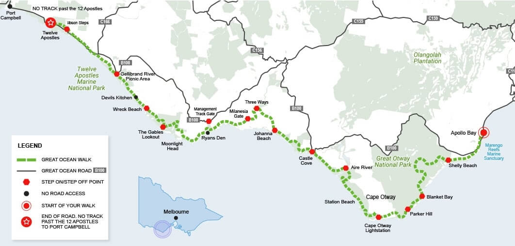
The Great Ocean Walk is officially 104km, but you can expect to walk up to 109km – 112km in total. There is an option to walk around the lighthouse grounds, to explore small paths to the lookout points and Rainbow Falls, and where possible you may walk out to the pick up spots(roads and car parks). The walk ends at the 12 Apostles. You cannot walk on to Port Campbell as there is no track.
The Great Ocean Walk Map is available as a booklet or a fold-out map and is included in the price of your walking package with Walk91. BUY HERE!
You can step off the track at the following points:
Marengo, Shelly Beach, Blanket Bay, Parker Hill, Cape Otway Lighthouse, Aire River, Castle Cove, Johanna Beach, Milanesia Gate (3 ways), Ryans Den Management track, The Gables, Wreck Beach, Princetown, 12 Apostles. Please get in touch if you have any further questions. And take a look at our entire range of Self-guided Great Ocean Walk Tours.
Approx kms for Walk 91 itineraries:
Apollo Bay to Shelly Beach – 8km
Shelly Beach to Blanket Bay – 14km
Blanket Bay to Cape Otway – 10.5km
Cape Otway to Castle Cove – 17.5km
Castle Cove to Milanesia Gate – 16km
Milanesia Gate to The Gables – 18km
The Gables to Twelve Apostles – 19.5km
Approx kms between camping spots that do not involve leaving the track:
Apollo Bay to Elliot Ridge Great Ocean Walk Campsite: 10km
Elliot Ridge to Blanket Bay Great Ocean Walk Campsite: 12km
Blanket Bay to Cape Otway Great Ocean Walk Campsite: 11km
Cape Otway to Aire River Great Ocean Walk Campsite: 10km
Aire River to Johanna Beach Great Ocean Walk Campsite: 14km
Johanna Beach to Ryans Den Great Ocean Walk Campsite: 14km
Ryans Den to Devils Kitchen Great Ocean Walk Campsite: 13km
Devils Kitchen to 12 Apostles: 16km
Total distance 100km